Before adding the direction finding function, the Bluetooth location service solution identifies the distance between two Bluetooth devices and determines the object location only by relying on the received signal strength information (RSSI). Since only meter distance accuracy can be achieved, only the approximate position can be determined.
Bluetooth direction finding function
Bluetooth 5.1 core specification has the optional function of detecting signal direction. The Bluetooth device with this function can determine the direction and signal accuracy (that is, the angle at which the identification signal reaches the receiver or the angle at which the signal leaves the transmitter) by identifying the signal angle, and can achieve centimeter level position accuracy.
This technology will strongly promote the development of proximity solutions. By using low-power Bluetooth RSSI, the proximity solution can more accurately determine the distance between two Bluetooth devices. For example, museums and retailers can send relevant proximity point information to visitors: when the user approaches the display cabinet / store / shelf, the Bluetooth tags or beacon attached to it can send relevant data to the user's smartphone. The data may be the information of a work of art or the buy one get one free promotion activities that users often go to the store.

Imagine that when you walk into a museum, there are many exhibits with beacon in one exhibition hall. With the support of Bluetooth direction finding function, you can know the relevant information of all exhibits through the app on your mobile phone; When you want to know about a particular exhibit, just point your mobile phone to it and you can get more information about the exhibit.
At the same time, these new functions will also greatly enhance the performance of asset tracking and indoor navigation and positioning system, and solve the pain point that GPs can not be used indoors. The direction finding function allows the real-time positioning system (RTLS) to more accurately confirm the location of nearby equipment. For example, in the factory and warehouse environment, the Bluetooth beacon located around the facility can communicate with the Bluetooth tag on the asset in the warehouse to confirm the location of a pallet or forklift. Such beacons in large shopping centers can locate smart phones and help users find specific stores, restaurants or nearest toilets.
Over the years, the positioning system has relied on Bluetooth technology to confirm the device position and achieve meter level position accuracy. Nowadays, with the enhancement of location service by Bluetooth direction finding function, the positioning system can identify the signal strength and direction to determine the position of the device at the same time, and improve the accuracy to centimeter level.
Trilateration and triangulation
Real time positioning system (RTLS) uses Trilateration and triangulation to determine the position of equipment. The trilateral measurement method is very suitable for locating the tray with Bluetooth tag in the warehouse or the medical equipment in the hospital. It calculates the distance between three or more transmitters in the facility and the tagged equipment according to the TOF ranging method, According to the calculation results, this distance is converted into the position coordinates of the target equipment.
Although trilateral measurement can also be used in shopping centers or stadiums navigation solutions, triangulation with Bluetooth orientation function can provide more accurate solutions. The triangulation method determines the position of the smartphone according to the angle of the signal sent or received by the fixed position device. Of course, developers can also combine these two methods to improve the positioning accuracy, and estimate the position and distance of the equipment more accurately by using the angle of arrival (AOA) and angle of departure (AOD) positioning methods and RSSI at the same time.
Angle of arrival
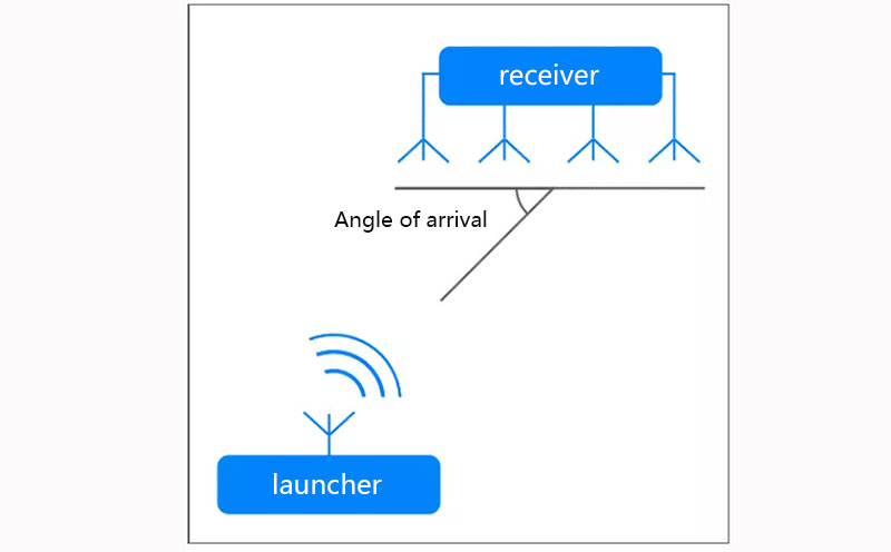
The angle of arrival positioning method (AOA) is used to track mobile transmitters attached to mobile personnel / equipment, such as warehouse forklifts or hospital patients. When calculating the distance using the angle of arrival, the transmitter uses a single antenna to transmit the signal, and the receiver uses multiple antenna arrays to estimate the transmission angle of the signal. The angle of arrival is calculated according to the phase difference when each antenna receives the transmitted signal. Since the distance between the antennas is fixed and known, the direction of the equipment can be estimated.

Bluetooth direction finding using angle of arrival (AOA) method
Departure angle
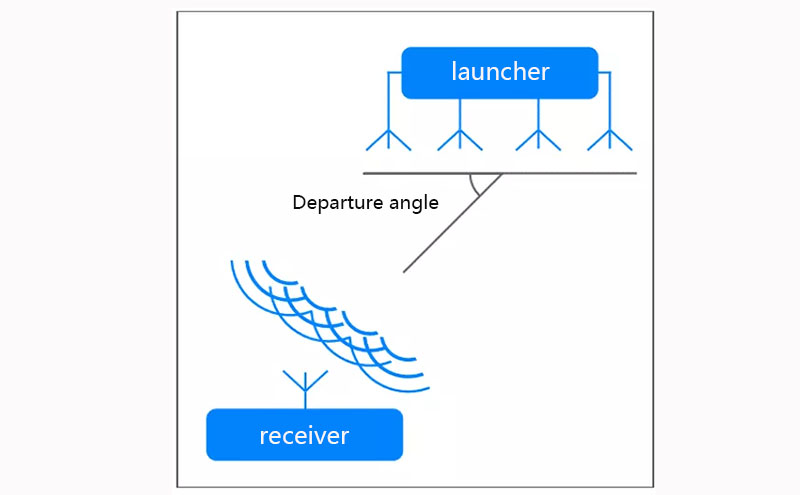
Opposite the angle of arrival is the angle of departure. Facilities such as gymnasiums use departure angles to track the location of visitors' smartphones and provide them with venue navigation. Generally, the position of the transmitter is fixed and sends signals to all nearby smartphones. The smartphone obtains the signal direction from the departure angle data and converts it into the location on the map in the application, so that visitors can easily find the route in the venue.

Bluetooth direction finding using angle of departure (AOD) method
When calculating the distance using the starting angle, the transmitter is equipped with multiple antennas and the receiver is equipped with a single antenna. Multiple antennas of the transmitter will continuously switch and transmit data alternately. The receiver samples the data of the transmitter, and then calculates the angle and direction of the transmitter according to the known antenna array and sampling information.
If you have any questions, please contact us by the following ways